
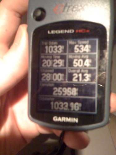
This past week I used my Garmin GPS unit in the air on my flight back from Boston and MASSCUE to Oklahoma City, as well as on a drive today from OKC up to Kansas for Ron Prince’s final football game as head coach at Kansas State. This was the first time I’ve used the GPS unit in the air. This photo shows our altitude at 25,958 feet above sea level on our descent into the Oklahoma City area:
One of my classmates from the Air Force Academy used to fly U-2s at Beale AFB in California, and flew T-38s for proficiency. He told me back in the late 1990s (I think it was around 1998) that his handheld Garmin GPS unit was far superior to the antiquated guidance avionics in the T-38, so he actually used his GPS unit for navigational purposes. I found that amazing.
That was probably the second time I’d heard about using a handheld GPS in the air for flight navigation. When I lived and studied in Mexico City during 1992-93, I flew up to San Antonio at one point with a state department official who was also assigned to the U.S. embassy in Mexico City. He was a co-owner of a private plane, and we were joined by a former Air America pilot who was in private business in Mexico. I remember two main things about our flight:
- The former Air America pilot had loaded a bunch of large, ceramic pots into the back of our small aircraft. The state department pilot was concerned the weight limit for our aircraft might be exceeded by this additional cargo. (Density altitude should be a concern of every pilot, of course.) I remember the Air America pilot telling the state department official, “Don’t worry, it looks fine. We’ll be good.” And with that evaluation, we went ahead and took off… We didn’t have any problems on the flight to San Antonio… thankfully! It was a bit hair raising to fly in a small plane with a pilot taking advice which amounted to “kick the tires and light the fires” — It certainly made for a memorable trip!
- I also remember that the state department official used a handheld GPS unit to navigate us from the airport near of Mexico City into San Antonio. Those were the days when “selective availability” for GPS was still enabled, which was “intentional, slowly changing random errors of up to a hundred meters (328 ft) in the publicly available navigation signals.” Knowing we were using a civilian GPS receiver, I was a little concerned we were relying exclusively on GPS for navigation and not even using an alternative like VOR navigation as a backup. Thankfully, everything turned out just fine for our flight.
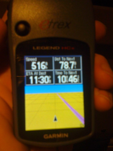
Traveling with a GPS unit can be enlightening. The GPS unit calculates your live groundspeed, and it’s a lot more impressive to watch speed statistics in a commercial airliner than in a private automobile. This photo shows our groundspeed was 516 miles per hour on our descent into Oklahoma City!
Last summer, when we were driving as a family to camp in New Mexico, my son was using our GPS unit and one point and was monitoring our speed. It was a different experience to hear him ask from the back seat, “Dad, what is the speed limit here?” That question was followed up by him informing me of my current groundspeed, according to the GPS unit. A new type of family accountability on a road trip! 🙂
I thought of my GPS unit when I was flying from Minneapolis down to Oklahoma City Wednesday night this week, and I looked out the window to see the lights of a large city. My GPS unit shows cities in close proximity to my current location, and I was able to figure out I was looking down at the lights of Wichita, Kansas. Very cool.
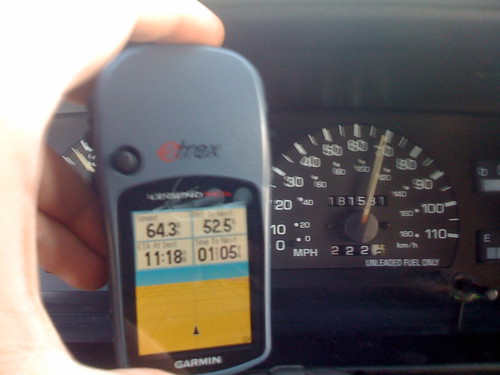
Today as I drove up to Manhattan, Kansas, I pulled out my GPS unit again and compared the calculated groundspeed to the speed shown on my speedometer. My GPS unit indicated that my speedometer is about 4 mph slow.
My geocaching experiences with my GPS unit have been pretty limited to date. (1 – 2 – 3) The power of GPS is stunning, however. I hope in the years to come as my kids go further in Boy and Girl Scouting we’ll use GPS together more. When we’re on vacation together, hopefully we can make time to do more geocaching!
Technorati Tags:
gps, geocaching, travel, garmin
If you enjoyed this post and found it useful, subscribe to Wes’ free newsletter. Check out Wes’ video tutorial library, “Playing with Media.” Information about more ways to learn with Dr. Wesley Fryer are available on wesfryer.com/after.
On this day..
- Using the Daum Equation Editor to Format Math Equations for Wolfram Alpha – 2012
- Google Tools Workshops in Oklahoma City: 14-15 December 2010 (flyer) – 2010
- How to publish an audio lecturecast with Podcast Generator (screencast demo) – 2010
- Meet Jonney Shih, Netbook innovator – 2009
- Power of Google Voice Transcriptions comes to YouTube with Automatic Annotations – 2009
- 1963 to 2007: Broadcasting has come a long way – 2007
- Oklahoma centennial photos, videos, and reflections – 2007
- Create a skype button – responsibly – 2007
- Residential wifi proliferates – 2007
- 3rd grade website about Africa – 2006
Comments
4 responses to “GPS learning in the air and on the highway”
I had a lot of fun with my GPSr on a few plane trips. One to Norway. Then on one flight I was told that I had to turn it off. It was not a flight approved device. Oops. It was fun while it lasted.
Hope that you will get to do lots of Geocaching with your kids. What a great family hobby. Problem solving, treasure hunts, interesting places and lots of great family time.
Aren’t GPS receivers on the list of things you can’t use on a commercial airliner at any time? Did you get special dispensation?
Bernie: That is an excellent question — as of May 2008 according to GPSinformation.net Northwest Airlines (which is the carrier I was flying with last week) DOES officially approve of GPS units in flight at cruise altitude, when use of approved electronic devices is permitted. I have not seen that in writing on a Northwest Airlines website or asked a Northwest employee that question, however. Next time I fly I will.
Does anyone else have any other links or info about this issue?
Did a little research and found that GPSrs might be OK to use on some airlines. Need to check with each airline to know for sure. It was a lot of fun to follow my flight this way. Hope that I will be able to do it again.