
In preparing for week 4 of the Wednesday night class I’m teaching this term on Google Earth at our church, I discovered the website and Google Earth layer Panoramio. Panoramio is one of three layers which come with Google Earth under the top category “Geographic Web.”
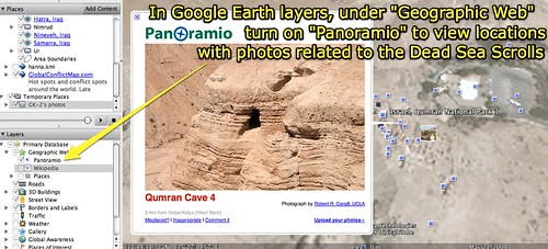
Photographs are submitted by Panoramio’s users to be included in Google Earth as geo-tagged blue dots. In Google Earth, users can click a dot and view embedded photos which are located at approximately the location on earth where they were taken.
The current wait for a new photo to be approved in Panoramio is approximately one month. We had a question tonight in class about whether or not anyone could post any photo to Panoramio. The answer appears to be yes, anyone can submit a photograph, but there is not a guarantee that every submitted photo will be approved and actually show up in GE. The Panoramio acceptance policy provides more details about why photos are or are not selected for inclusion.
Another notable geographic resource we explored this evening was a collection of 23 three dimensional buildings created for Ancient Rome. These have been created by various individuals using Google SketchUp, and are examples of Geo-referenced models included in Google’s 3D Warehouse.
Technorati Tags:
panoramio, geography, google, earth, googleearth
If you enjoyed this post and found it useful, subscribe to Wes’ free newsletter. Check out Wes’ video tutorial library, “Playing with Media.” Information about more ways to learn with Dr. Wesley Fryer are available on wesfryer.com/after.
On this day..
- Applying STEM Skills with Robotic Sphero Balls (Donor’s Choose Project) – 2014
- Teens use Facebook primarily for private purposes – 2010
- Different Purposes for Using of Digital Tools to Teach Literacy in the College Classroom by Richard Beach – 2010
- Social Media Counter updated for September 2010 – 2010
- Standalone WiFi Skype Phones and Rocket Scientists – 2009
- Critical for Ning site administrators to address spam – 2009
- Visual Tapestry – Flight – 2009
- Seeking the elusive “inbox zero” – 2007
- Universities banning Skype – 2006
- Portaportal and flexibly learning new tools – 2006
Comments
One response to “Visually exploring earth with Panoramio”
I did not know that you could do this on Google. Of course, I am not surprised these days. Modern Technology is so astounding. This would be wonderful in a geography class or even a physical science class. The geography part would be good for students to make a connection with the places they are learning about. It would no longer be just a picture in a book. They could actually interact with it. As far as the physical science aspect, students could better under the physical things about a location. They could draw conclusions about the climate among other things. This could help their critical thinking skills. I like that a teacher or even one of the students could submit a photo. Personally submitting the photo would make the student more involved in the learning process. I really like this.