
I received an email this evening from a participant in my half-day workshop, “GeoApps for Learning: Google Maps and Google Earth,” which I presented in early March at the Heartland eLearning Conference. He is running into trouble getting his students to add images to their shared, custom Google Map. These are a few tips I sent him. Custom Google maps are created by clicking MY MAPS on maps.google.com after you login to the site.
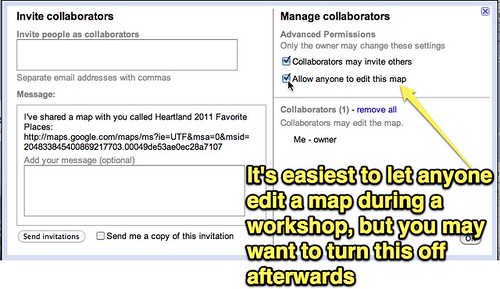
First, make sure you setup your Google Map for collaboration / shared editing. If you don’t have the map set for everyone to edit it, you’ll need to add each student by email address (using the same email they use for their free Google Account) so they can have edit rights to the map. Click the COLLABORATE link on the map to change these settings.
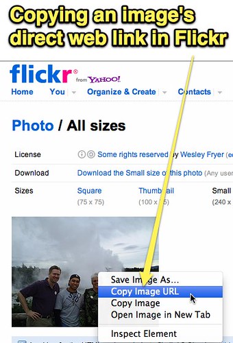
The image you want to add within a placemark in Google Maps needs to be saved somewhere online so you can add it by web link. Google Maps doesn’t provide image hosting, like Google does for other services like Google Sites and Google Docs. You add the image with it’s direct link, starting with “http://” and ending in “.jpg” You’ll want to copy that image link FIRST before trying to add it to the map.
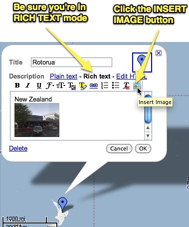
Once you (or a student) clicks EDIT on the map, make sure you’re in RICH TEXT mode and click INSERT IMAGE.
The image should then appear in your placemark. Click SAVE and DONE when you finish editing. That’s it!
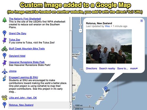
This is the collaborative map workshop participants and I created during our time together at Heartland eLearning.
View Heartland 2011 Favorite Places in a larger map
Collaboratively edited Google Maps like this are a great way for students in one class or different classes to cooperatively add links as well as rich media content (images and YouTube videos) to a project.
I love geography, maps, and Google Maps! Creating shared maps like this is a super way to “talk with media.”
Cross-posted to “The Infinite Thinking Machine” and “Talk with Media.”
Technorati Tags:
google, share, map, gct, collaborate
If you enjoyed this post and found it useful, subscribe to Wes’ free newsletter. Check out Wes’ video tutorial library, “Playing with Media.” Information about more ways to learn with Dr. Wesley Fryer are available on wesfryer.com/after.
On this day..
- David Jakes on Learning Spaces (April 2016) – 2016
- Scratch Camp Facilitator Workshop (April 2016) – 2016
- Understanding Why eBooks “Feel Different” – 2013
- Separate Wifi Access Point Works Best with Apple TV on Busy Network – 2012
- How do you feel about students bringing laptops to class? – 2010
- Learners and teachers as tour guides – 2008
- Comments I had missed – 2007
- Rethinking WalMart Patronage – 2007
- Bill and Melinda are Terrified – 2006
- Tearfully Slow Bandwidth – 2006
Comments
4 responses to “Tips for adding images to Custom Google Maps #gct”
Hello my name is Chase Davidson and I am a student of Dr. Strange’s at the University of South Alabama. I just wanted to say thanks for your informative post on extra ways that Google maps can be used to personalize it to your own wants and needs. I didn’t know that your could personalize Google maps like this. Thanks again for the post>.
Thanks for the reminder of your Kiwi visit. We are having to hold both our premiere NZ conferences in Rotorua now because the earthquake in Christchurch has destroyed so much of the infrastructure that it is impossible to hold such a large scale conference. I loook forward to the day when we can once again come together in the South Island.
Students have be 18 or older is that not right?
In the United States FERPA mandates students need to be 13 to have their own social networking profile. Some schools obtain signed parent permission for mail accounts (including gmail) so students can obtain them who are less than 13. So in the United States, it’s NOT accurate to say students have to be 18 to use Google Maps with a personal account that permits them to save maps/profile info.