
These are my notes from John Bailey‘s workshop on Google Earth and Google Maps at the September 26, 2011, Google Geo-Teacher Institute in Lewiston, Maine. John wasn’t our only presenter, we also learned with/from others… MY THOUGHTS ARE IN ALL CAPS.
John Bailey’s Google Earth resources (not all recently updated) – http://snap.uaf.edu/earth/
John Bailey is an Assistant Research Professor at the University of Alaska Fairbanks (UAF). He holds a PhD in Volcanology and Remote Sensing from the University of Hawaii, and was previously a postdoc at the Alaska Volcano Observatory. John currently works for the Scenarios Network for Alaska Planning (SNAP), a climate change education and research group in UAF’s Geography Department. He specializes in creating geovisualizations for education/outreach, and teaches workshops on how to use Google Earth. He also created and teaches the first accredited university class in Google Earth and KML. He spends his spare time traveling and playing floorball.
KML = code used to create content in Google Earth (Keyhole Markup Language)
– we’re going to use GUI interfaces in Google Earth to create KML files
Google Maps interface changes often because it CAN: all you need is a browser, no software needs to be downloaded
I really like to navigate with the keyboard with both Google Maps and Google Earth
– Google Earth keyboard shortcuts
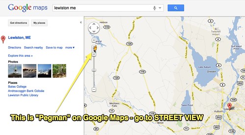
“Pegman” takes you to street view in Google Maps
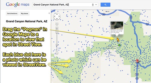
Google has special boats and bikes to collect street view images from places like National Parks (like the Grand Canyon)
– drag the Pegman to places where photos have been taken
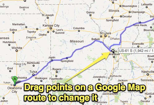
Get directions in Google Maps is great for many reasons, including the way you can drag your route and change it!
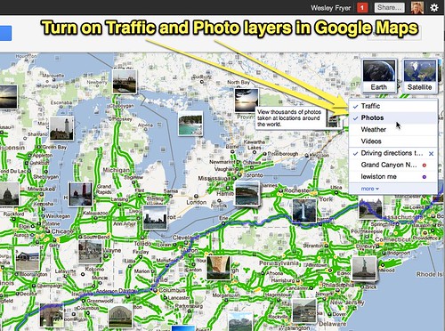
Turn on layers like traffic and photos in Google Maps
Google Maps has shaded elevation layers, that layer is not currently in Google Earth
The Google Earth Plugin gives you the ability to embed a version of Google Earth right in Google Maps, on your browser
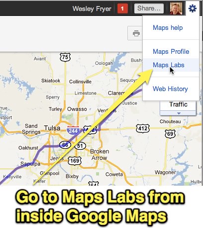
Google Labs are being closed as its own area, and moved into the respective “departments” or areas of Google
Example: Maps Labs
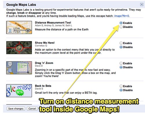
Turn on distance measurement tool in Maps Labs:
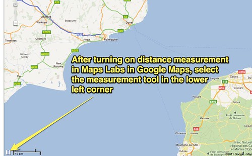
After it’s activated, click the distance measurement tool in Google Maps in the lower left corner:
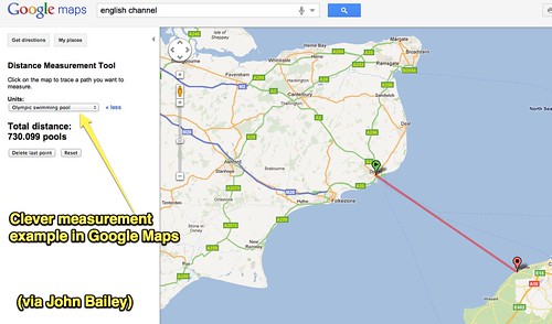
You can click “I’m feeling Geeky” to choose alternate measurement units in Google Maps, just like you can with Google Earth. Example: How many Olympic Swimming pools is the distance across the English Channel?
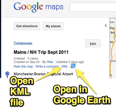
Customized Google Maps can also be exported as KML, then you can open it in Google Earth
– some people find it easier to create KML files within Google Maps
– remember the COLLABORATIVE option within maps in Google Maps (can’t do that kind of realtime collaboration within Google Earth)
Fusion Maps can be used with both Google Maps and Google Earth
Google Maps can be used to create KML files, and you can open a Google Map directly in Google Earth using provided links/buttons:
Folks vetting pictures for Panoramio don’t like having people in them for privacy reasons (you can share your photos)
– wait time is 4-6 weeks to get photos on Panoramio (Jerome Burg found 2-3 days can be waiting time)
– you can submit photos which show that PLACE
80 million trees are modeled in Google Earth and growing… and they are species specific models!
3D Tours is available in the Google Earth Gallery
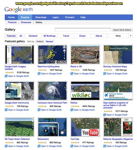
Also remember you can do an advanced Google search for KML/KMZ files by file type
Google works with National Geographic on Project Blue for current expeditions
The Google Earth 3D Trees forest Collection is awesome!
Tip: use COMMAND and arrow keys on a mac to tilt up or down in Google earth
Video: New Seafloor in Google Earth Tour
Keyboard
N = north
U = up
R = up and north at the same time!
Utilize the help resources in Google Earth!
– great things written in the Google Earth Community!
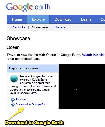
Explore the Ocean in Google Earth (and download KML file)
The creator of the Google Earth blog is ex-NASA and makes a 6 figure income from the site… he’s now touring the world on his yacht. Nice!
Don’t make your Google Earth place marks in the SEARCH panel, instead make them in the PLACES panel so they can be saved
Best practices:
– when you are working on a KML project in Google Earth, save your file OUT from Google Earth frequently
– also quit Google Earth periodically and re-open it
– it can crash and you’ll lose stuff when that happens… so backup often!
One of my test questions for students: Name 8 ways you can create a place mark in Google Earth (there are about 11 ways to do it!)
Great example shown by John (not online yet) is a National Geographic lesson plan “Go with the Flow” which has connected elevation info with position data on a river, showing how elevation changes with location on a South American river (this will be released/announced soon)
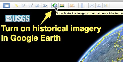
Turn on historic imagery in Google Earth
Placemark hierarchy
– point placemark
– path / linestring
– polygon
– model
Great “official” recommended Geo-blogs for new info from Tina O:
– Google Lat Long Blog
– Official Sketchup Blog
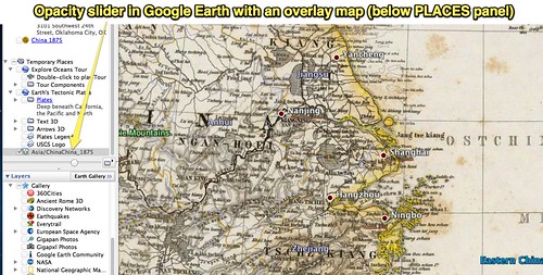
Overlays are VERY powerful for Google Earth
– USGS Topographic Map Overlay
Another source of free topo maps: http://mapserver.mytopo.com
Because of map projection differences, it’s often necessary to stretch and tweak maps
Historical maps which tell a story can be great to use as overlays in Google Earth in the classroom
Rumsey Historical Maps are a built-in layer of overlays in Google Earth’s Gallery
Looking at chance over time in the cultural as well as physical environment is very interesting
– 1903 Klamath Basin is an example with a map overlay
Opacity slider is at the bottom of the PLACES panel in Google Earth. This is an example of an 1875 Rumsey historical map of China
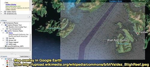
Great activity: Overlay this WikiPedia commons image on Google Earth searching for “bligh reef, valdez alaska” (reef where the Exxon Valdez ran aground)
Tutorial: Adding Overlays to Google Earth from www.virtualfieldwork.org/How_tos/How_tos.html
Remember when you are in “tour mode” in Google Earth, until you close out of it the tools at the top will be greyed out
MY CLOSING LINKS:
– I started a Twitter list related to Geography: twitter.com/wfryer/geography/members
– Here are Geography-related blogs I follow (a Google Reader bundle)
PLEASE SHARE OTHER GOOGLE EARTH / SKETCHUP RELATED SITES AND RESOURCES YOU LIKE WHICH ARE NOT HERE. 🙂
Technorati Tags: earth, geography, google, howto, institute, map, maps, teacher, gti
Comments
2 responses to “Google Earth and Google Maps GTI Workshop (Sep 2011)”
Thanks for the summary – and reminding me there are lots of broken links needing fixing on /earth 😉