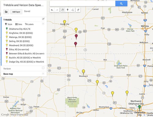
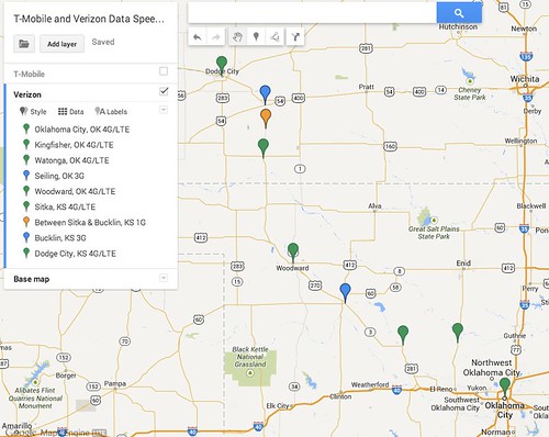
Sunday afternoon and evening I drove from Oklahoma City to Dodge City, and I noted the cellular data speeds available from T-Mobile on my iPhone5s and from Verizon on my JetPack mobile hotspot on the trip. I used Google Map Engine Lite to create a GeoMap comparing the results. This is the map key / legend I used, which I also included in the GeoMap label for each waypoint:
- Green: 4G/LTE
- Blue: 3G
- Yellow: 2G (EDGE)
- Orange: 1G
- Red: no service
Here are the T-Mobile results:
Here are the Verizon results:
This GeoMap shows why people living in rural areas of the midwest are well-advised to stick with Verizon instead of T-Mobile as a cellular provider at the present time. I was pleasantly surprised at how much 4G/LTE coverage there is now for Verizon in rural Oklahoma and rural Kansas. I know wireless coverage of rural Kansas is much worse with AT&T than Verizon, because Verizon bought AllTel a few years ago. AllTel had the best cell tower coverage in rural Kansas, so now Verizon does. Based on past experiences, AT&T has better rural coverage in Oklahoma than T-Mobile did yesterday, but I can’t confirm if the same level of 4G/LTE coverage is there now. That’s why each provider has updated maps of their own cell and data coverage… but it’s very interesting to collect data on these results personally and compare them.
I would have used custom icons for each placemark/waypoint, but Google Map Engine requires an upgrade to the PRO version for $5 per month to add custom icons. At this point I don’t think my needs justify that expense.
The craziest thing that happened on my drive up was that my 10 year old was able to successfully call me via FaceTime, when I was still on 3G Verizon service south of Dodge City. My video didn’t show up for her because my upstream bandwidth was so limited, but I was able to see hers and she could hear me. FaceTime videoconferencing isn’t possible when connecting over 3G directly from an iPhone, but when you connect via wifi through a cellular hotspot it is. Clearly we’re living in the 21st century when video calls like this from rural America are possible!
Based on these data measurements and experiments today, I’m definitely opting to keep my Verizon MiFi / mobile hotspot for cellular data service when I travel in the Midwest.
The sunset on Sunday night just south of Woodward, Oklahoma, was one of the prettiest I’ve seen in a long time. I took this photo with my iPhone5s using the Pro HDR app, and did not apply a filter.
Learn more about creating GeoMaps and view links to more examples on the GeoMaps page of Mapping Media to the Common Core.
Technorati Tags: speed, tmobile, verizon, geomap, rural, hotspot, comparison, bandwidth, edge, 4G, LTE, EDGE


