
Today was, without a doubt, the most adrenaline-inspiring drive on an Interstate highway I’ve experienced to date in my life. It’s ironic today’s experiences driving west on I-40 from Oklahoma City to Amarillo came on the heels of last night’s post, “The lure of iReporter fame encourages dangerous tornado chasing.” I was thinking as we saw tornadic winds directly over us on the Interstate that we weren’t stormchasing or seeking these experiences– we were just trying to get to Amarillo!
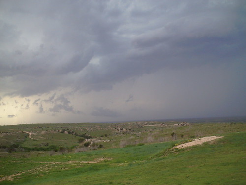
About 80 miles west of Amarillo we sighted what I thought must be a fairly well defined wall cloud. My wife was driving at the time, so I was able to snap a few photos and take some video before she finally pulled over under a bridge and had me take the wheel.
Generally I think most of our midwestern storms tend to track from southwest to northeast, but that did not seem to be the case with this storm today. This past Wednesday in Oklahoma City, we had tornados reported in the southern part of the county which tracked south. This storm today appeared to track south as well. I thought we were going to be fine and just skirt the southern edge of it as we stayed on Interstate 40. (The old Route 66.) I thought wrong.
I had photographed the wall cloud off to the northwest, and was working on printing some equipment labels for next week’s Celebrate Oklahoma Voices workshop. My wife told me to put down the label printer and look at the clouds. To my amazement, low, whiter scud clouds were not only moving south across the Interstate, but as we looked up they also were starting to rotate. Yikes!
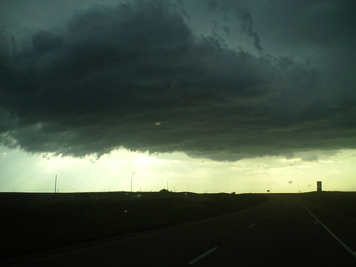
I took this first video as we started to notice the lower clouds moving south over the Interstate.
This second video shows some of the rotation we saw today, directly above us on I-40. (A few more are available in my Flickr set from today’s drive.) This video doesn’t do the experience justice. It was pretty scary stuff.
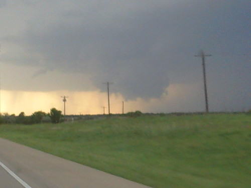
After switching drivers under a bridge shortly after I took these videos from the passenger’s seat, the rain and wind got very strong and made visibility poor. We were able to drive out of the storm, thankfully, and came to the Texas rest area about 60 miles east of Amarillo. I took several photos of the storm off to the northeast and east from the parking lot. I thought this first image of the clouds behind the rest area was particularly striking.
Eventually we were able to drive completely out of the storm, but we were still under some ominous, overhanging dark clouds for 10 miles or so.

In the rest area, I briefly visited with some other travelers who were eastbound. They reported they had just seen FIVE tornados just north of I-40, close to Groom, Texas. I’ve never heard of five tornados coming out of the same storm, at the same time. I’ve heard about the 1979 Wichita Falls tornado, which was actually a tornado that started as three different twisters which combined forces to create a devastating F5. I can’t be sure, but I suspect the wall cloud I photographed initially may have been responsible for those tornados north of Groom.
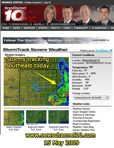
Amarillo-area doppler radar shows this line of severe storms is continuing to track southeast tonight.
I won’t be assuming again, when I see a wall cloud as we did today, that the storm is tracking northeast.
Glad we are all safe and sound.
Technorati Tags:
storm, video, weather, cloud, wall, wallcloud, severe
If you enjoyed this post and found it useful, subscribe to Wes’ free newsletter. Check out Wes’ video tutorial library, “Playing with Media.” Information about more ways to learn with Dr. Wesley Fryer are available on wesfryer.com/after.
On this day..
- Disruptive Decentralization in Social Media and AI – 2023
- Learning and Recovering From Failure in STEM Class – 2014
- Professional Digital Publications Archive Project – 2012
- Putting the Passage of Amendment 10-A for Christians Worldwide in Statistical Perspective – 2011
- Editing Video with iMovie taken on a Sony HandyCam mini-DVD Camcorder – 2011
- No Internet Election Campaigns for NJHS Candidates in Lubbock – 2011
- Join me for “Powerful Ingredients” over Ustream tomorrow – 2009
- Presentations from Richardson, Texas this morning – 2008
- Geocaching in the Classroom – 2008
- links for 2008-05-15 – 2008
Comments
8 responses to “A Scary Wall Cloud and Rotation Over I-40 Today”
Same line of storms that started just south of us this afternoon. Trudy drove IN it along I-70 most of the way to Liberty — on her way to Hawaii via KC tomorrow. I was watching her on Loopt. Only a few drops here, but big hail south & east.
Glad she is OK. I sure wasn’t expecting the storm to track south. I totally thought we were safe since it was off to the north. 🙁
Here is 1 additional video which initially didn’t transcode properly when I uploaded it to Flickr. This was actually the first video I shot in this series. The storm had a surreal aquamarine color that I hadn’t seen before. Lots of powerful lightning strikes also.
Hey there – I agree, those stormclouds are scary to see when you’re on the open road! Glad you got home safely. In terms of the tracking, I always assumed the opposite (that they tracked somewhat south) since the midwest is the “tornado alley” and a lot of weather tracks in southerly rotation from Canada. Lived in Kansas during a big tornado season (year of the OK city mile-wide) so know what you mean about watching the rotation above you! Hope this isn’t a bad season for y’all –
Here’s another pic, this one I snapped with my iPhone. I forgot to take my iPhone cable on the trip, so I couldn’t upload this one last night. I named this, “The dark storm approaches.”
Looks like a prize-winning photo to me! You should submit it … somewhere?
WOW! Thats kool! But also scary. Were you all scared when you were driving under that storm? I’m a geography major possibly climatology minor and i want to pursue a career in meteorology possibly storm chasing. Is it like a really hard job?
Yes, it was definitely pretty scary driving under those rotating clouds. I actually chose geography as one of my majors in college because I thought I might want to go into meteorology as well. I’m not an official “stormchaser” so I can’t really answer the question on how hard of a job it is. I’m sure it’s exciting! I hope to interview some “real” stormchasers at some point and get their perspectives on it.